 |
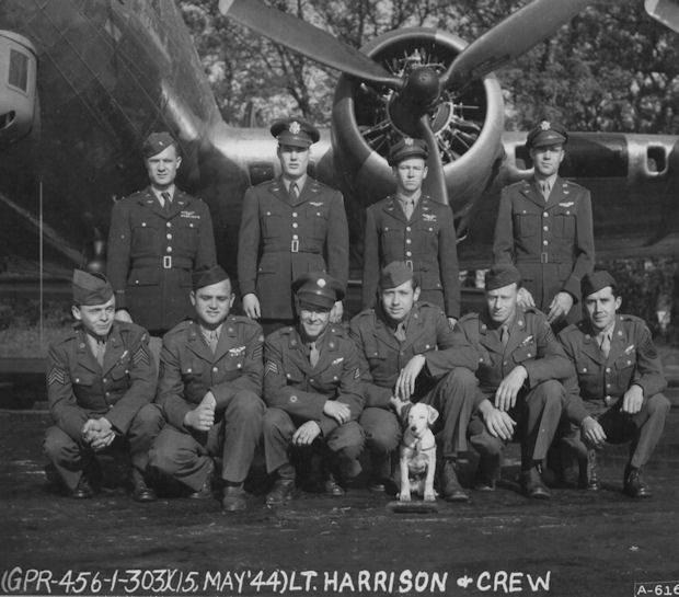
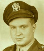
359th Harrison Crew Weldon O. Harrison, Pilot |
Personnel
Mission Reports

WELDON O. HARRISON CREW - 359th BS
(Harrison assigned 359BS; 04 Feb 1944 - Photo: March 1944)
(Upgraded from CoPilot, Arthur J. Hybert Crew, to Pilot: 26 March 1944)
(Back L-R) 1Lt Weldon O. Harrison (P), 2Lt William G. Moyer (CP),
2Lt Robert L. Bates (N), 2Lt Loren F. Rawlings (B)
(Front L-R)
Sgt Robert W. Hanson (R),
Sgt Earl D. Salmon (BT).
Sgt Lyman E. Ela, Jr. (E),
Sgt John L. Arendt (WG),
Sgt Theodore G. "Ted" Miller (TG),
Sgt Calvin G. Turkington (WG)
As CoPilot: 22 Dispatched (21 Credited) missions: 2Lt Arthur J. Hybert (P) - 16 credited missions - 87 (11 Dec 1943), 88, 93, 95, 98, 101, 102, 103, 104, 106, 107(A), 108(AS), 111, 112, 113, 114 (2 March 1943); 2Lt Leroy E. Daub (P) - 4 credited missions (92, 97, 124, 131; 1Lt Elmer W. Young (P) - 1 credited mission (121; 1Lt Billy M. Goolsby (P) - 1 mission
As Pilot: 6 credited missions: 2Lt William G. Moyer (CP) - 144 (29 April 1944), 146, 148, 149, 150, 151 (11 May 1944).
For mission dates and targets see the missions list. (A) Aborted Non-credited mission -- (AS) Credited abortive sortie - Turned back over Belgium - bombs not dropped.
Crew Note:
1Lt Weldon O. Harrison (P) - Co Pilot with four different Pilots. Flew as
a Lead Crew CoPilot on the 11 February 1944 Schweinfurt, Germany mission.
Upgraded from CoPilot to Pilot on orders dated 26 March 1944. First mission
as 1st Pilot on 29 April 1944, flew with the 336th BS - couldn't find the 303rd BG(H) formation.
Combat tour completed on 11 May 1944.
Most of the Harrison Crew members were originally part of the Frederick L. Rowan Crew. See the Rowan Crew page and the information below.
EN ROUTE FROM THE UNITED STATES - B-17G #42-97553
by Frederick L. Rowan, Pilot
 The flight of Aircraft #297553 originated in Kearney, Nebraska where each crew of the Schmidt Provisional group was to receive a new B-17G and fly it to Prestwick, Scotland. The Rowan crew received the above numbered aircraft.
The first day we were to fly to Grienier AAB in New Hampshire. Of the 90 crews that left Kearney, Neb., that day only the first few ever got to Grienier on schedule. We (crew #83) were one of the last to take off - about 09:00 hours AM - when we neared Albany, New York, we were advised to turn back as there was a severe storm over the Hudson River with clouds stretching up to 50,000 ft. The weather below us was not good. We were advised to check in by radio and land wherever weather conditions would permit. I contacted Rochester, Buffalo, Cleveland and was advised they were ceiling zero and to proceed west. When I contacted Detroit they advised me their ceiling was 600 feet and to descend and land at Romulus AAFB, which I did breaking out over Detroit at exactly 600 feet. We found ourselves over the Ford River Rouge Airport and 15-20 of our planes had landed there. I proceeded another 20 or so miles and landed at Romulus AAB. Those at River Rouge eventually had to take off and proceed to Romulus. We stayed there nearly a week before the weather cleared and we then proceeded to Grienier AAFB in New Hampshire.
The next day we departed and flew up to Gander AAFB, Newfoundland. En route #3 engine gave us oil pressure problems as the indicator suddenly fell to zero. We feathered the prop and came into Gander on three engines. We then had to wait for repairs. The problem continued and we spent over three weeks there as they had to get a new prop from the states. After a two hour test flight it finally seemed that #3 engine was ready for the transatlantic crossing. The oil pressure appeared o.k.
We were scheduled along with seven other B-17G aircraft to make the crossing on February 20, 1944. Takeoff was scheduled for 02:00 hours (AM). I remember Sgt. Roughly called the tanker crew trucks back to top off the gas tanks - a move we were all thankful for later that day. At the briefing the weather office advised us of a storm about 2 1/2 - 3 hrs. out, but we could climb above it at 30,000 ft. With that information we took off at approximately 02:00 hrs. and proceeded East toward Prestwick, Scotland. We were approximately two hours into our flight when #3 engine started having oil pressure problems - it soon dropped to zero. It was necessary to feather the engine again. Had anyone been clairvoyant, we would have returned to Gander, but having had a long delay at Grander (23 days) decided to continue the flight.
With one engine feathered, it soon became obvious we could not fly above the storm due to power loss as our briefing officer suggested. We therefore decided to level off at 23,000 feet and go though the top of it. Within the next five minutes several dramatic completely unexpected things occurred. The first was a jolt, like lightning struck us and we were suddenly in a spin losing altitude rapidly. This could also have been caused by a stall or a sudden downdraft. The flight indicator and other instruments were also completely useless. The flight indicator was locked perpendicular to the horizontal line and I had no idea if we were actually spinning to the right or left. I did know if we got into a flat spin we would not get out of it. At this point my co-pilot caged the flight indicator and re-set it. This indicator now worked and showed that we were in a sharp spin to the right and were rapidly losing altitude.
With the flight indicator functioning properly, I decided to push the nose down and push the left rudder. This slowly stopped the spin and we stopped losing altitude and soon had the plane flying straight and level. We were now down 15-20,000 feet and with the plane under complete control again I looked at the two compasses to resume an easterly flight.
Much to my surprise they now showed a 90 degree difference - the question now was which was correct. It could be the radio compass or the magnetic compass? Having no idea which was right and unable to get a position report from either my navigator (because of the cloud cover) or my radio operator (as the equipment in the radio room was not functioning) I decided to split the difference. This meant we would be flying 45 degrees off course until the sunrise or I could make radio contact with Prestwick, Scotland and determine which quadrant we were in as my radio was completely operational. About two hours later the dawn slowly emerged over the Atlantic and I now had weak radio contact with Prestwick, also a strong radio signal from Iceland. This proved we were flying N.E. and necessary corrections had to be made to hit the beam and fly onto our destination. Then the final unexpected happened--engine number two had a sudden drop in oil pressure and that left us half way across the ocean with only two engines functioning, off course, and uncertain as to how far we were from Prestwick.
Our attention was now directed to the gas gauges as we transferred the gas from engine 2 and 3 to engines 1 and 4. To lighten the load we also threw all personal baggage out the rear fuselage door. The Prestwick radio signal kept gaining strength as we now flew southeast, but as time passed we still did not see land. The gas gauges kept getting dangerously lower.
As we continued across the ocean we reached the radio beam for Prestwick and both engines that were left (#1 and #4) were doing fine but both gas needles were getting critically lower. We had been in flight nearly 12-13 hours when in the distance land was sighted--guess we all knew how Columbus felt when he sighted America in 1492.
We were now presented with a critical decision. We had the choice of trying -to reach Prestwick by flying across Ireland and the Irish sea hoping we could make the airport before running out of gas. If we failed we would crash en route having absolutely no control over the events that would follow or we could land here while we still had some gas in the outboard engines. One more glance at the gas gauges and the decision was made--land here as best we could. There appeared to be four possibilities--land on a nearby road which was a one lane dirt road with trees on both sides (immediately discarded), land on the beach parallel to the ocean--fly out about a mile, land in the water and use our life rafts to get ashore or circle out about a mile and fly directly towards the beach at about 110-120 M.P.H. We would cut the engines as soon as we were over shallow water and hope for a smooth wheels up landing ending up near or on the beach. We chose the latter.
We circled out wide and after the crew was in crash position we proceeded in at about 10-20 feet altitude towards the beach ahead. As we got close to the water one last unexpected surprise awaited us. There were huge green-grey rocks, above and below the water and also on the beach ahead. Any one of which if hit by our aircraft, could rip the plane apart and easily cause injury or loss of life. At this point we were nearing the beach and had to land. I told my co-pilot to open his escape window by several inches so he could get to his lifeboat. I did the same as the rocks seemed everywhere and could easily jam our escape hatch. We approached the beach at about 110-120 m.p.h. and had to land the plane quickly. We were too low to pull up without the possibility of hitting hills to our right, left or straight ahead.
As one large rock appeared ahead, I pulled the plane upward about five feet--one rock was on the beach dead ahead. This was it so I hit the water and hoped for the best. There were no hidden rocks under the water and a very smooth landing resulted. Regarding the life rafts the one on my right worked fine--the other one didn't, but we were all soon safely ashore and well received by our temporary Irish hosts. At long last the flight of U.S.A.A.F. #297553 was over after approximately 13-14 anxious hours in the air.
[Researched by Historian Harry D. Gobrecht]